Volume 1 KLCP2020 explains the 8 Development Cores in achieving the vision of making Kuala Lumpur a world-class City in 2020, namely:
1) Dynamic World Class Business City
3 Strategic Direction
9 Major Initiatives
2) Communication & City Accessibility
3 Strategic Direction
15 Major Initiatives
3) Use Sustainable Land
3 Strategic Direction
7 Major Initiatives
4) City Life Environment
3 Strategic Direction
11 Major Initiatives
5) Protecting and Enhancing the Environment
3 Strategic Direction
7 Major Initiatives
6) Improve the Green Ring and Blue Corridor
3 Strategic Direction
6 Major Initiatives
7) Personal Image and Identity
3 Strategic Direction
11 Major Initiatives
8) Green Infrastructure
3 Strategic Direction
7 Major Initiatives
Volume 2 : Development Control
Volume 2 of KLCP2020 contains two components that form the basis for development control in Kuala Lumpur. The two components are:
Development Control Plan
Planning Control Layer Plan
2 maps used to control the use and development intensity of the entire Kuala Lumpur area are:
DCP 1 – Land Use Zone Map
Control over the use of land and buildings
DCP 2 – Intensity Map
Control over density and maximum plot ratio
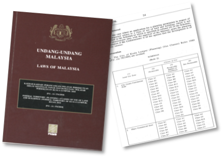
Perlu dibaca bersama Kaedah-Kaedah (Perancangan) Wilayah Persekutuan (Kelas Kegunaan Tanah Dan Bangunan) (Wilayah Persekutuan Kuala Lumpur) 2018
DCP 1 – Land Use Zone Map
Control over the use of each land lot
DCP 2 – Intensity Map
2 Forms of Intensity Control
Density control for Residential Zones:
Kawalan Nisbah Plot Maksimum Dibenarkan (Zon Perdagangan) :
Planning Control Layer Plan
Selain daripada Pelan Kawalan Pembangunan (DCP 1 & 2), Pelan Lapisan Kawalan Perancangan juga menjadi asas kawalan pembangunan di dalam PBRKL2020
Riverside Corridor Planning Control Layer
Height Limit Planning Control Layer & Transit Planning Zones
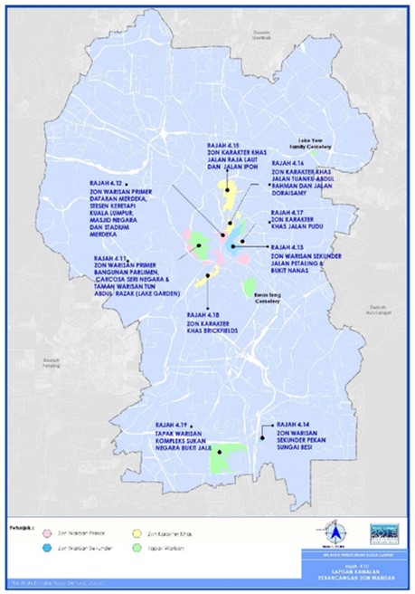
Planning Control Layer Heritage Zone
How to Read Land Use & Intensity Zone Map
The Land Use Zone Map (DCP 1) and Intensity Map (DCP 2) are shown in a 1:5,000 scale grid which allows them to be focused for easier and clearer reference
The following Planning Control Layers are marked on both the Land Use Zone Map and the Intensity Map:
A simple step-by-step guide on how to reference a grid-scale plan
Methods (Planning) Federal Territory (Land Use and Building Class) (Wilayah Persekutuan Kuala Lumpur) 2018
Read together with the Land Use Zone Map which sets out activities that are permitted, permitted with conditions and not permitted
There are 5 Main Classes which are detailed into 47 activities