21 November 2024 05:52:20 PM

Kuala Lumpur Development Plan 2040

Kuala Lumpur City Plan 2020

Hierarchy

Development Plan

Where is the hierarchy of KLSP and PTKL in the development plan?

Town Planning Act 1976

(Act 172)

National Level

Development Plan :

3rd National Physical Plan

Contents :

National Planning Policy

Area Coverage :

Semenanjung Malaysia & Sabah

Federal Territories (Planning) Act 1982

(Act 267)

Federal Territories Level

Development Plan :

Kuala Lumpur Structure Plan 2040

Contents :

Kuala Lumpur Planning and Development Policy and Strategy

Area Coverage :

Wilayah Persekutuan Kuala Lumpur

Local Level

Development Plan :

– Pelan Bandar Raya Kuala Lumpur 2020
– Pelan Strategik Dewan Bandaraya Kuala Lumpur 2015-2020

Contents :

Planning Area

Area Coverage :

Covering Strategic Zone Areas throughout the Federal Territory of Kuala Lumpur

Special Area Level

Development Plan :

Kampong Bharu Development Detailed Master Plan

Contents :

Master Plan (Detailed Lot Planning)

Area Coverage :

Covering the Strategic Zone Area throughout Kuala Lumpur

Local Plan According to Act 267

According to section 13(1) of the Federal Territory (Planning) Act 1982 (Act 267)

If the structural plan for the Federal Territory has come into force, the Datuk Mayor shall as soon as practicable consider, and thereafter always pay attention to the need to prepare a draft local plan for any part or for the entire Federal Territory and, if he deems it necessary and he has not yet done so, shall prepare the draft local plan.

In addition, there are several other sections in Act 267 that relate to the process involved in forming a Local Plan, namely:

  • Section 16

    Acceptance And Publication Of Draft

  • Section 17

    Changes, Repeals And Replacements of Draft Local Plans

Pengalaman Penyediaan
Pelan Bandaraya Kuala Lumpur 2020

Proses Pewartaan Pelan Bandaraya Kuala Lumpur 2020

  • Januari - Ogos 2013


    Penerimaan Menteri

    Datuk Bandar bersetuju dengan "Notis Pemberitahuan Penerimaan Draf PBRKL2020"
    Y.B Menteri memutuskan untuk menangguh perwartaan DPBRKL2020

  • September - November 2013


    Taklimat Pindaan DPBRKL2020

    Memberi taklimat DPBRKL2020 (pindaan) kepada wakil rakyat dan mendapatkan maklumbalas

  • April 2015


    Pindaan DPBRKL2020

    Pindaan dikemukakan kepada YB Menteri dengan ambilkira data pembangunan komited 2015
    YB Menteri memutuskan untuk menangguhkan perwartaan PBRKL2020

  • Mei 2018


    Rujukan Dalam DBKL

    DPBRKL2020 dicetak dan dijadikan sebagai rujukan dan kegunaan dalaman DBKL dalam proses penilaian perancangan

  • Jun 2018


    Mengemaskini Data Kelulusan Perancangan

    Mengemaskini secara berterusan data pembangunan komited berdasarkan kepada kelulusan perancangan

About

Kuala Lumpur City Plan 2020 (KLCP2020)

The application of KLCP2020 has come into effect from the date of its publication on 30 October 2018.

KLCP2020 is a plan stipulated in terms of legislation to be used by the Mayor of Kuala Lumpur in controlling development in Kuala Lumpur.

Strategic Directions and Initiatives displays strategic directions and initiatives towards achieving the vision of making Kuala Lumpur a world-class City in 2020.

The Kuala Lumpur Development Control Plan translates the strategic direction and initiatives in Volume 1.

Volume 1: Strategic Directions & Incentives

Volume 1 KLCP2020 explains the 8 Development Cores in achieving the vision of making Kuala Lumpur a world-class City in 2020, namely:

1) Dynamic World Class Business City

3
Strategic Direction

9
Major Initiatives

2) Communication & City Accessibility

3
Strategic Direction

15
Major Initiatives

3) Use Sustainable Land

3
Strategic Direction

7
Major Initiatives

4) City Life Environment

3
Strategic Direction

11
Major Initiatives

5) Protecting and Enhancing the Environment

3
Strategic Direction

7
Major Initiatives

6) Improve the Green Ring and Blue Corridor

3
Strategic Direction

6
Major Initiatives

7) Personal Image and Identity

3
Strategic Direction

11
Major Initiatives

8) Green Infrastructure

3
Strategic Direction

7
Major Initiatives

0

Strategic Direction

0

Major Initiatives

Volume 2 : Development Control

Volume 2 of KLCP2020 contains two components that form the basis for development control in Kuala Lumpur. The two components are:

2 maps used to control the use and development intensity of the entire Kuala Lumpur area are:

DCP 1 – Land Use Zone Map

Control over the use of land and buildings

DCP 2 – Intensity Map

Control over density and maximum plot ratio

Perlu dibaca bersama Kaedah-Kaedah (Perancangan) Wilayah Persekutuan (Kelas Kegunaan Tanah Dan Bangunan)
(Wilayah Persekutuan Kuala Lumpur) 2018

DCP 1 – Land Use Zone Map

Control over the use of each land lot

Main Land Use
Land Use Zone
1. Trade
1. Downtown Commerce
2. Main Trade
3. Trade
4. Local Trade
2. Mixed Development
5. Mixed Development
6. Development of Mixed Industry
3. Residence
7. Residence 1
8. Residence 2
9. Residence 3
10. Traditional Village
11. Stable Housing
12. Public Housing
4. Industry and Special Industry
13. Industry
14. Technology Park
5. Institutions
15. Institution
6. Green Area
16. Public Open Area
17. Private Open Space
18. Forest Reserve
7. Others
19. Public Facilities
20. Pengangkutan
21. Infrastructure and Utilities
22. Cemetery

DCP 2 – Intensity Map

2 Forms of Intensity Control

Density control for Residential Zones:

Residential Land Use Zone
Maximum Allowable Density
One Acre Per Person (ose)
Acre Unit
R1
4
12
24
40
1
3
6
10
R2
48
80
120
12
20
30
R3
160
240
320
400
40
60
80
100
Traditional Village
Subject to the guidelines specified in the Development Guide Plan for each Traditional Village
Public Housing
400
100

Kawalan Nisbah Plot Maksimum Dibenarkan (Zon Perdagangan) :

Land Use Zone
Abbreviation
Maximum Plot Ratio Allowed
City Center Commerce
CCC
Maximum 1 : 10
Main Trade
MC
Maximum 1 : 8
Trade
C
Maximum 1 : 9
Local Trade
LC
Maximum 1 : 7
Mixed development
MX
Maximum 1 : 10
Industrial Mixed Development
MXI
Maximum 1 : 4
Industry
IP
Maximum 1 : 2
Technology Park
TP
Maximum 1 : 2
Institution
INT
Maximum 1 : 8

Planning Control Layer Plan

Selain daripada Pelan Kawalan Pembangunan (DCP 1 & 2), Pelan Lapisan Kawalan Perancangan juga
menjadi asas kawalan pembangunan di dalam PBRKL2020

Riverside Corridor Planning Control Layer

Height Limit Planning Control Layer & Transit Planning Zones

Planning Control Layer
Heritage Zone

How to Read
Land Use & Intensity Zone Map

The Land Use Zone Map (DCP 1) and Intensity Map (DCP 2) are shown in a 1:5,000 scale grid which allows them to be focused for easier and clearer reference

The following Planning Control Layers are marked on both the Land Use Zone Map and the Intensity Map:

  • Land Use Zone Map

    a) Riverside Corridor
    b) Heritage Zone
  • Intensity Map

    a) Altitude Control
    b) Transit Planning Zone

A simple step-by-step guide on how to reference a grid-scale plan

Methods (Planning)
Federal Territory
(Land Use and Building Class)
(Wilayah Persekutuan Kuala Lumpur)
2018

Read together with the Land Use Zone Map which sets out activities that are permitted, permitted with conditions and not permitted

There are 5 Main Classes which are detailed into 47 activities
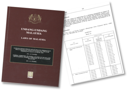
5 Classes of Use

  • Class A

    Activities in the form of residences, quarters, hostels, nursing homes and businesses from home.

  • Class B

    Business and office activities.

  • Class C

    Activities in the form of industry and services.

  • Class D

    Activities in the form of public and community facilities.

  • Class E

    Activities in the form of transportation and utility facilities.

KLCP2020 Digital Document

KLCP2020 - Volume 1
KLCP2020 - Volume 2

Kuala Lumpur City Hall

Contact us

Copyright © 2024 Kuala Lumpur City Hall – City Planning Department

Date of update : 21 November 2024
Total Number of Visitors : 135086
Skip to content